
Velodyne Lidar-sensoren voeden de Hovermap van Emesent om voorbij de visuele gezichtslijn te vliegen
Emresent’s AL2 voor Hovermap maakt gebruik van Velodyne Lidar om toegang te krijgen tot de ontoegankelijke
SAN JOSE, Californië – (BUSINESS WIRE) – Velodyne Lidar, Inc. heeft vandaag aangekondigd dat Emesent’s nieuw geïntroduceerde Autonomy Level 2 (AL2) -technologie voor Hovermap Velodyne lidar-sensoren gebruikt voor realtime perceptie en hoogwaardige, nauwkeurige 3D-gegevens. Hovermap is een plug-and-play mapping en autonomie-payload voor industriële drones die autonome vlucht mogelijk maakt in gebieden buiten de visuele zichtlijn (BVLOS) en zonder GPS-connectiviteit.
De AL2-technologie gebruikt Velodyne’s Puck LITE lidar als de primaire perceptie- en kaartsensor. Dit maakt autonome verkenning, navigatie en lidar-mapping mogelijk in uitdagende ontoegankelijke omgevingen zoals mijnen, civiele bouwwerken, telecommunicatie-infrastructuur en rampenbestrijdingsomgevingen. Als onderdeel van de gelijktijdige lokalisatie- en mapping (SLAM) gebaseerde autonomiestapel van Emesent, zorgt AL2 ervoor dat drones buiten het communicatiebereik vliegen, zelf navigeren en obstakels zoals dunne draden en takken vermijden.
AL2 kan worden bediend vanaf de start tot de landing door slimme waypoints in te stellen in een live 3D-kaart die naar een tablet wordt gestreamd. Hierdoor kunnen operators op veilige afstand blijven van gevaarlijke omgevingen zoals wenkbrauwen, randen van hellingen, besloten ruimtes en hoogtes. De rijke gegevens van de Puck LITE-sensor stellen bedrijven in staat betere gegevensinzichten te krijgen over hoe ze mijnen en andere omgevingen veilig kunnen maken.
Velodyne Lidar Sensors Power Emesent’s Hovermap to Fly Beyond the Visual Line of Sight
Emesent’s AL2 for Hovermap Leverages Velodyne Lidar to Access the Inaccessible
SAN JOSE, Calif.–(BUSINESS WIRE)– Velodyne Lidar, Inc. today announced that Emesent’s newly introduced Autonomy Level 2 (AL2) technology for Hovermap uses Velodyne lidar sensors to provide real-time perception and high-quality, accurate 3D data. Hovermap is a plug-and-play mapping and autonomy payload for industrial drones that enables autonomous flight in areas beyond visual line of sight (BVLOS) and without GPS connectivity.
This press release features multimedia. View the full release here: https://www.businesswire.com/news/home/20200730005182/en/
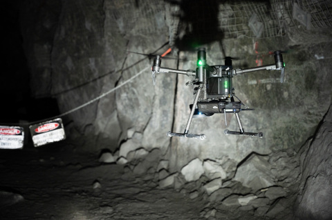
Emesent’s Autonomy Level 2 (AL2) technology for Hovermap, using Velodyne’s lidar sensors, enables companies to rapidly map, navigate and collect data in challenging inaccessible environments such as mines, civil construction works, telecommunications infrastructure and disaster response environments. (Photo: Emesent)
The AL2 technology uses Velodyne’s Puck LITE lidar as the primary perception and mapping sensor. This allows autonomous exploration, navigation and lidar mapping in challenging inaccessible environments such as mines, civil construction works, telecommunications infrastructure and disaster response environments. As part of Emesent’s simultaneous localization and mapping (SLAM) based autonomy stack, AL2 powers drones to fly beyond communications range, self-navigate and avoid obstacles including thin wires and branches.
AL2 can be operated from take-off to landing by setting smart waypoints in a live 3D map streamed to a tablet. This allows operators to remain a safe distance from hazardous environments such as brows, stope edges, confined spaces and heights. The rich data from the Puck LITE sensor enables companies to gain better data insights on how to make mines and other environments safe.
“The Velodyne Puck LITE is simply a sensational sensor for creating drone-based mapping and autonomy solutions because of its compact size, light weight and performance – all critical for drone-mounted systems,” said Dr. Stefan Hrabar, Emesent CEO. “The sensor was an essential ingredient in helping us to create game-changing new technology that can obtain vital data in challenging environments in real time without risking the machine or operator safety.”
Emesent is an Automated with Velodyne partner at the forefront of GPS-denied drone autonomy. The company recently placed fourth in the urban circuit of the DARPA Subterranean (“SubT”) Challenge together with the Robotics and Autonomous Systems Group at the Commonwealth Scientific and Industrial Research Organization (CSIRO) and Georgia Institute of Technology.
“Emesent’s innovative use of Velodyne’s lidar sensors is helping to deliver valuable data and insights that were previously impossible to access,” said Jon Barad, Vice President of Business Development, Velodyne Lidar. “In addition to what they provide today to the mining, infrastructure, survey and mapping industries, it is exciting to consider how this innovation will help usher in a new era of autonomous drone operation across a variety of other industries.”
In the United States, the Federal Aviation Administration (FAA) currently has restrictions on drones flying beyond the visual line of sight. Emesent’s technology innovation could potentially usher in a new era of safe, autonomous drone flight – not only in mines but everywhere.
Velodyne Puck LITE sensors deliver a high-resolution image to measure and analyze indoor and outdoor environments. Designed for applications that require a sensor with a low weight and compact size, the Puck LITE delivers outstanding resolution and performance for mobile and UAV/drone applications. It provides a full 360-degree environmental view to deliver real-time 3D data.
About Velodyne Lidar
Velodyne provides smart, powerful lidar solutions for autonomy and driver assistance. Headquartered in San Jose, Calif., Velodyne is known worldwide for its portfolio of breakthrough lidar sensor technologies. Velodyne’s founder, David Hall, invented real-time surround view lidar systems in 2005 as part of Velodyne Acoustics. Mr. Hall’s invention revolutionized perception and autonomy for automotive, new mobility, mapping, robotics, and security. Velodyne’s high-performance product line includes a broad range of sensing solutions, including the cost-effective Puck™, the versatile Ultra Puck™, the autonomy-advancing Alpha Prime™, the ADAS-optimized Velarray™, and the groundbreaking software for driver assistance, Vella™.
About Emesent
Emesent is a world-leader in drone autonomy, lidar mapping and data analytics. Founded in 2018, Emesent has since built a reputation for delivering high-quality data capture in the mining, infrastructure, survey and mapping industries. Their flagship product, Hovermap, is a smart mobile scanning unit that combines advanced collision avoidance and autonomous flight technologies to map hazardous and GPS-denied environments. Hovermap is uniquely versatile, it can be handheld, drone- or vehicle-mounted to map challenging, inaccessible areas. With a wide range of applications, Hovermap is being used by customers around the world.
View source version on businesswire.com: https://www.businesswire.com/news/home/20200730005182/en/
Contacts
Landis Communications Inc.
Sean Dowdall
(415) 286-7121