
Velodyne Lidar-sensoren versterken 3D-gegevensvastlegging in nieuw NavVis VLX-kaartsysteem
Velodyne Lidar maakt nauwkeurige en krachtige mobiele mapping mogelijk
SAN JOSE, Californië – (BUSINESS WIRE) – Velodyne Lidar, Inc. heeft aangekondigd dat het NavVis VLX draagbare mobiele indoor-kaartsysteem, dat vandaag is gelanceerd, is uitgerust met Velodyne lidar-sensoren om hoogwaardige gegevensregistratie van 3D-metingen aan te bieden. NavVis VLX is ontworpen voor het vastleggen van de realiteit in complexe gebouwde omgevingen zoals bouwplaatsen en torens met meerdere niveaus.
Dit persbericht bevat multimedia. Bekijk hier de volledige release: https://www.businesswire.com/news/home/20200512005188/en/
Elk NavVis VLX-systeem gebruikt twee Puck LITE™ -sensoren om puntenwolkgegevens vast te leggen die nodig zijn om bouwdocumentatie te creëren, waaronder plattegronden, 3D-modellen en digitale tweelingen. NavVis VLX combineert Velodyne-beeldgegevens met NavVis-technologie voor simultaneous localization and mapping (SLAM) om puntwolken van meetkwaliteit te leveren met een mobiel apparaat. Dankzij het compacte, veelzijdige ontwerp kan het systeem kleine, gefragmenteerde en smalle ruimtes in kaart brengen, evenals omgevingen met veel obstakels en oneffen terrein.
Velodyne Lidar Sensors Power 3D Data Capture in New NavVis VLX Mapping System
Velodyne Lidar Enables Accurate and Powerful Mobile Mapping
SAN JOSE, Calif.–(BUSINESS WIRE)– Velodyne Lidar, Inc. announced the NavVis VLX wearable indoor mobile mapping system, launched today, is equipped with Velodyne lidar sensors to provide high-quality data capture of 3D measurements. NavVis VLX is designed for reality capture in complex built environments such as construction sites and multi-level towers.
This press release features multimedia. View the full release here: https://www.businesswire.com/news/home/20200512005188/en/
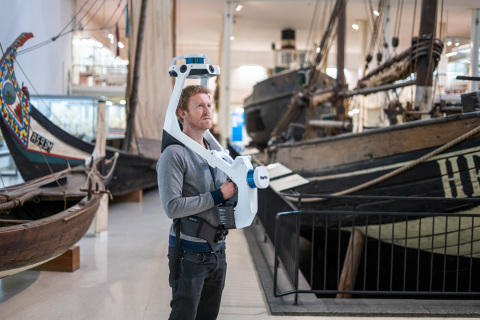
NavVis VLX, equipped with Velodyne lidar sensors, provides a new design for wearable mobile mapping that enables fast, targeted scanning in the most complex environments. (Photo: NavVis)
Each NavVis VLX system uses two Puck LITE™ sensors to capture point cloud data needed to create building documentation including floorplans, 3D models and digital twins. NavVis VLX combines Velodyne image data with NavVis simultaneous localization and mapping (SLAM) technology to deliver survey-grade point clouds with a mobile device. Its compact, versatile design enables the system to map small, fragmented and narrow spaces as well as environments with many obstacles and uneven terrain.
“Velodyne sensors provide real-time 3D data to our mobile mapping systems. This valuable input has played an important role in developing the industry-leading SLAM algorithms that power our flagship mobile mapping system, NavVis M6,” said Georg Schroth, NavVis CTO. “Now we are launching NavVis VLX, a complementary device that features the same ground-breaking SLAM technology in a compact, versatile design. We are very happy to have Velodyne be part of our efforts to provide laser scanning professionals with fast, efficient tools for scanning buildings that are capable of delivering survey-grade results.”
“NavVis mobile mapping systems capture the data needed for as-built documentation, such as 3D models and floorplans as well as realistic digital factories for enterprise manufacturing facilities. Stakeholders can inspect, document and share information about buildings and factories to track milestones, plan relocations and improve both customer and employee experience,” said Erich Smidt, Executive Director Europe, Velodyne Lidar. “The NavVis VLX system strongly demonstrates how the performance, range and compact form factor of Velodyne sensors enable companies to build innovative systems. The solution addresses specialized mobile mapping needs of AEC companies, surveyors and laser scanning professionals.”
Velodyne Puck LITE sensors deliver a high-resolution image to measure and analyze indoor and outdoor environments. Designed for applications that require a sensor with a low weight and compact size, the Puck LITE delivers outstanding resolution and performance for mobile and UAV/drone applications. It provides a full 360-degree environmental view to deliver real-time 3D data.
About Velodyne Lidar
Velodyne provides smart, powerful lidar solutions for autonomy and driver assistance. Headquartered in San Jose, Calif., Velodyne is known worldwide for its portfolio of breakthrough lidar sensor technologies. Velodyne’s founder, David Hall, invented real-time surround view lidar systems in 2005 as part of Velodyne Acoustics. Mr. Hall’s invention revolutionized perception and autonomy for automotive, new mobility, mapping, robotics, and security. Velodyne’s high-performance product line includes a broad range of sensing solutions, including the cost-effective Puck™, the versatile Ultra Puck™, the autonomy-advancing Alpha Prime™, the ADAS-optimized Velarray™, and the groundbreaking software for driver assistance, Vella™.
About NavVis
NavVis is a leading global provider of indoor spatial intelligence technology and solutions for enterprises, trusted by top companies including BMW, Daimler, Allianz, Lenovo and Deutsche Telekom. NavVis helps enterprises drive efficiencies and optimize business performance through its powerful digital twin platform for the indoors that enables accurate mapping at unprecedented speed and scale, immersive 3D visualization designed for collaboration and location-based apps that pioneer AI-powered positioning technology. Founded in 2013, NavVis is headquartered in Munich and has offices in New York and Shanghai. For more information, visit www.navvis.com.
View source version on businesswire.com: https://www.businesswire.com/news/home/20200512005188/en/
Contacts
Media Contact
Landis Communications Inc.
Sean Dowdall
(415) 286-7121