
Copernicus: gemiddelde oppervlaktetemperatuur op de aarde zet absoluut nieuw record in juli
READING, Engeland–(BUSINESS WIRE)– De gemiddelde absolute waarde van de luchttemperatuur dichtbij de oppervlakte van de aarde bereikte een nieuwe hoogte in juli 2016 volgens een analyse van de meteorologische datarecords van Europe’s Copernicus Climate Change Service uitgevoerd door het European Centre for Medium-range Weather Forecasts (ECMWF).
De temperatuur in de wereld piekt meestal in juli, wanneer de landmassa’s van het noordelijk halfrond gemiddeld op hun warmst zijn. Het varieert van meer dan 3 OC in de loop van elk jaar.
De grootste recente afwijking van dit jaarlijkse cyclus vond in februari dit jaar plaats, maar juli was nog steeds meer dan 0.5 OC warmer dan het 1981-2010 gemiddelde over deze maand. Dit maakte juli 2016 de warmste maand over alle datagegevens die teruggaan tot de negentiende eeuw.
Copernicus: Earth’s Average Surface Temperature Sets Absolute New Record in July
READING, England–(BUSINESS WIRE)– The average absolute value of the air temperature close to the Earth’s surface reached a new high in July 2016 according to an analysis of the meteorological data record by Europe’s Copernicus Climate Change Service operated by the European Centre for Medium-range Weather Forecasts (ECMWF).
This Smart News Release features multimedia. View the full release here: http://www.businesswire.com/news/home/20160810005418/en/
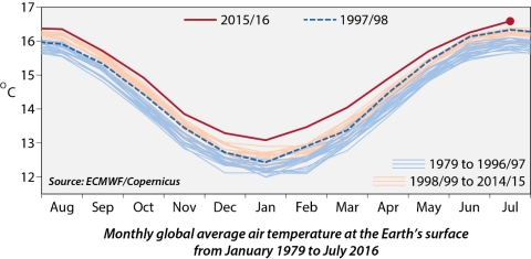 Monthly global average air temperature at the Earth’s surface from January 1979 to July 2016 (Graphic: Business Wire)
Global temperature usually peaks in July, when the land masses of the northern hemisphere are on average at their warmest. It varies by more than 3 OC over the course of each year.
The largest recent deviation from this annual cycle occurred in February this year, but July was still more than 0.5 OC warmer than the 1981-2010 average for the month. This made July 2016 the warmest month of any in a data record that can be extended back to the nineteenth century.
Each of the past twelve months was the warmest on record for that particular month. This came close to happening previously, from the month of August 1997 to July 1998. Prominent El Niño events, in which the atmosphere is heated by an unusually warm eastern tropical Pacific Ocean, occurred during both periods.
The 1997/98 event was a little stronger overall, but average air temperatures were higher during the more recent period because of the overall progression of global warming. Lower Arctic sea-ice extent in 2016 was an evident factor behind the larger temperature differences during northern winter months.
Natural variability of the climate system and changes induced by human activities play interacting roles that combine from time to time to give new extremes, such as have occurred over recent months.
Jean-Noël Thépaut, Head of the Copernicus Climate Change Service, said:
“These record breaking extremes are the result of a cocktail of weather phenomenon and human activity. There are higher than average temperatures over the vast majority of land and sea masses.”
“We’re already seeing the human cost of hotter conditions with the impact of reported wildfires and other changing local environments.”
Juan Garces de Marcilla, Director of Copernicus Services at ECMWF, added:
“As well as continuing to reduce emissions, in particular in the context of the Paris Climate Change deal, it is incumbent on policymakers to use the monitoring and predictive information provided by Copernicus and other programmes to plan resilience measures to adapt and mitigate the impact of climate change on industry and the public.”
Ends
More information including a temperature records over time animation is available at – http://climate.copernicus.eu/resources/data-analysis/average-surface-air-temperature-analysis
Web: ecmwf.int | atmosphere.copernicus.eu | climate.copernicus.eu
Notes to editors:
(i) Copernicus is the European Commission’s flagship earth observation programme that delivers freely accessible operational data and information services. The European Centre for Medium-Range Weather Forecasts (ECMWF) has been entrusted to implement two key parts of the Copernicus programme and is assisting with a third to bring a consistent standard to the measurement, forecasting and predicting of atmospheric conditions and climate change:
- The Copernicus Atmosphere Monitoring Service provides daily forecasts detailing the makeup composition of the atmosphere from the ground up to the stratosphere.
- The Copernicus Climate Change Service (in development) will routinely monitor and analyse around 20 essential climate variables to build a global picture of our climate, from the past to the future, as well as developing customisable climate indicators in relevant economic sectors.
- The Copernicus Emergency Management Service supports improvements to flood forecasting and understanding of the frequency, variability and consequences of extreme weather.
(ii) ECMWF is an international organisation which specialises in numerical weather prediction and is supported by many European states.
(iii) The quoted results are from ERA-Interim, a reanalysis of comprehensive sets of meteorological observations of the type analysed each day to initiate weather forecasts. It is produced by ECMWF and covers the period from 1979 onwards. It produces estimates of many meteorological and related surface variables in addition to surface air temperature. Additional estimates of atmospheric constituents and their sources and sinks are provided by specific systems operated by the Copernicus Atmosphere Monitoring Service.
(iv) The JRA-55 reanalysis produced by the Japan Meteorological Agency gives results for surface air temperature that are similar to those quoted from ERA-Interim.
(v) The conventional analyses of monthly climatological data produced by institutions such as the Met Office (with the University of East Anglia), NASA and NOAA provide long records of the monthly deviations of temperature from values for climatological reference periods, but not of absolute values of temperature. They show that the relatively warm spells that have occurred from the 1990s onwards are unprecedented over a period that stretches back as far as 1850 in the case of the Met Office and 1880 in other cases.
(vi) The US National Snow and Ice Data Center (NSIDC; http://nsidc.org/) provides comprehensive information on variations in sea-ice extent. The different estimates of sea ice concentration used by the ERA-Interim and JRA-55 reanalyses are broadly consistent with each other and with the information provided by NSIDC.
(vii) There are multiple indicators of the strength of an El Niño, based on temperature anomalies in different regions of the tropical Pacific Ocean and associated measures of the atmospheric circulation.
View source version on businesswire.com: http://www.businesswire.com/news/home/20160810005418/en/
Contacts
For Copernicus Climate Change Service:
Rory Edwards or Jack Thompson
Office: +44 (0) 20 7593 4000
Direct dial: +44 (0) 2075934020, +44 (0) 207 593 4005
Mob: +44 (0)7912 783 941, +44 (0)7912 783 939
rory.edwards@madano.com, jack.thompson@madano.com